Here’s a comprehensive outlook on the South Africa weather forecast for Tuesday, 14 November 2023.
Weather warnings and advisories to take note of on Tuesday, 14 November 2023
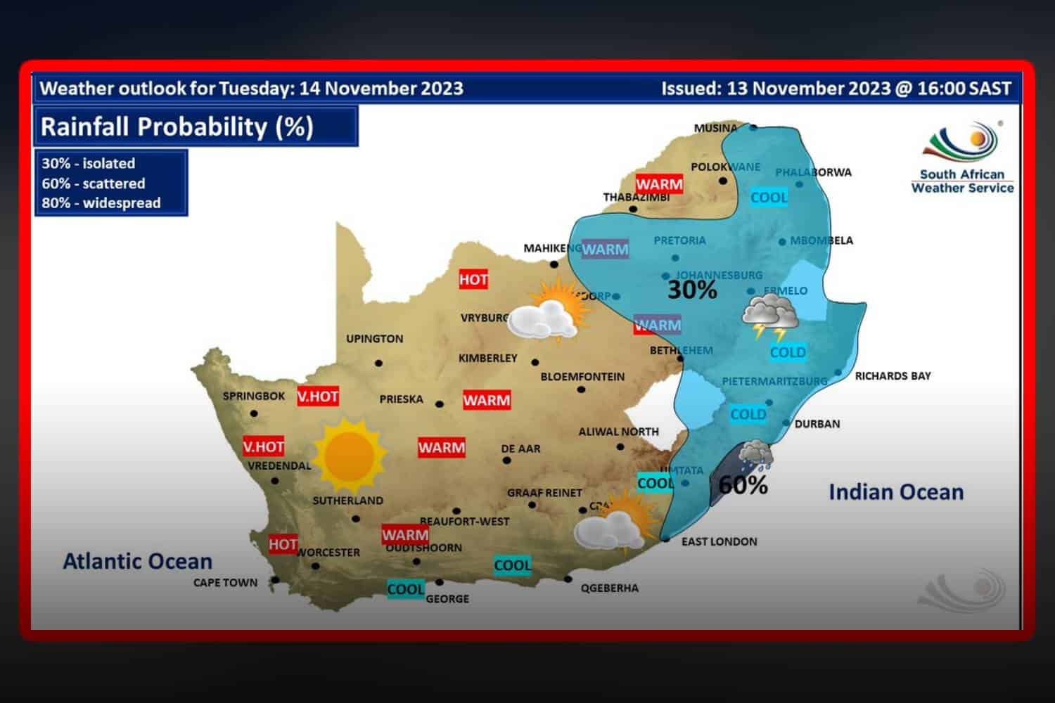
South Africa is set to experience varied weather conditions on Tuesday, with certain areas under high fire danger warnings.
Fire Danger Alert
Extremely high fire danger conditions are anticipated in Khai-Ma Municipality (Northern Cape), Matzikama, Cederberg, and Bergriver municipalities (Western Cape), and Dawid Kruiper Municipality (Northern Cape).
South Africa weather forecast: Here’s what to expect on Tuesday, 14 November 2023
Eastern Cape
In the eastern half, the day starts cloudy with light morning rain in the east but will clear up to a fine and cool day, warming in the southwestern interior. Coastal winds will start light south-westerly and become south-easterly by afternoon.
In the west, the morning may see cloudy conditions in interior places, then transitioning to a fine and warm day but cool along the coast. North-easterly winds will strengthen from fresh to strong easterly by midday.
Free State
The province will see cloudy conditions with morning fog patches in the far east, transitioning to a fine and cool to warm day. The east can expect isolated afternoon showers and thundershowers.
Gauteng
Expect partly cloudy skies and warm temperatures, with isolated showers and thundershowers. The UVB sunburn index is predicted to be very high.
KwaZulu-Natal
The weather will be cloudy and cool to cold, accompanied by isolated showers and thundershowers. Coastal winds will be light to moderate, southerly to south-easterly. The UVB sunburn index is high.
Limpopo
The morning will bring cloudy conditions with fog, drizzle, and occasional light showers and rain over the escarpment, clearing in the west by the afternoon.
Mpumalanga
The province will experience cloudy and cool to cold weather with morning fog, drizzle, and occasional showers and rain in places in the east, clearing to partly cloudy in the west in the afternoon. Isolated showers and thundershowers are expected over the Highveld and escarpment areas.
North West
The region will be fine and warm to hot, becoming partly cloudy in the east with isolated showers and thundershowers.
Northern Cape
The day will be fine, warm to hot, and very hot in the extreme north. Coastal areas will experience fresh to strong south-easterly winds.
Western Cape
Expect partly cloudy to cloudy conditions with mist in the extreme north-eastern parts in the morning, otherwise a fine and warm to hot day, very hot over the West Coast district. Strong southerly to south-easterly winds will blow along the coast. The UVB sunburn index is extreme.
We will continue to update this report as more information becomes available. Stay tuned for the latest weather news and advisories.