Here’s a comprehensive outlook on the South Africa weather forecast for Thursday, 16 November 2023
Weather warnings and advisories to take note of on Thursday, 16 November 2023.
Thursday’s South Africa weather forecast is expected to be marked by severe thunderstorms in multiple regions and extremely high fire danger conditions in parts of the Northern Cape and Western Cape.
Impact-Based Warnings
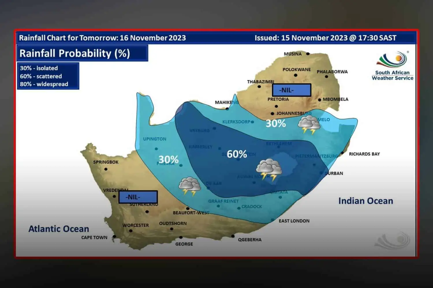
A Yellow Level 2 warning for severe thunderstorms with damaging winds and hail was issued for the Free State, extreme eastern parts of Northern Cape, central and western parts of the North West and southern KZN.
Moreover, a Yellow Level 1 warning for severe thunderstorms with damaging winds and hail was issued for the northern and eastern parts of the Eastern Cape
Fire Danger Warnings
Extremely high fire danger conditions are expected over the southern parts of the Northern Cape as well as the northeastern parts of the Western Cape.
Advisories
A heatwave with persistently high temperatures is expected in places over Mnquma, Mbhashe, Intsika Yethu, Engcobo, Alfred Nzo Local Municipalities, and OR Tambo District Municipalities, lasting until Saturday, 18 November 2023.
South Africa weather forecast: Here’s what to expect on Thursday, 16 November 2023
Eastern Cape
The western half of the Eastern Cape will be partly cloudy and warm, hot over the interior, with isolated afternoon thunderstorms in the north. Coastal winds will be fresh south-westerly, moderating in the afternoon.
In the east, partly cloudy and warm, turning hot over the interior with isolated afternoon thunderstorms but scattered thunderstorms along the north-eastern escarpment. The coast will have moderate south-westerly winds.
Free State
The morning will bring fog patches in places, then it will be fine and warm, turning partly cloudy in the east with isolated showers and thundershowers.
Gauteng
The morning fog patches will clear from the south, followed by cloudy and cool weather, warmer in the north, and becoming partly cloudy from the west by mid-morning.
An extreme UVB sunburn index is expected.
KwaZulu-Natal
Morning fog over the interior will give way to cloudy and cool conditions, turning cold in the southwestern high ground with isolated showers and rain.
Coastal winds will be moderate southerly to south-easterly, shifting to easterly to north-easterly in the south towards the evening. The UVB sunburn index is forecast to be low.
Limpopo
Expect cloudy and cool to warm conditions with isolated showers and rain over the central and eastern parts, clearing from the west.
Mpumalanga
The region will see cloudy and cool to cold weather with isolated showers and thundershowers, which will clear from the west.
North West
Morning fog patches will be seen in some areas, with fine and warm weather overall but partly cloudy in the east.
Northern Cape
The day will be fine and warm to hot, but cooler in the Namakwa district. Coastal winds will be fresh southerly, becoming strong by the evening north of Port Nolloth.
Western Cape
Cloudy over the eastern parts in the morning, with conditions becoming partly cloudy along the coast and adjacent interior from the afternoon, otherwise fine and cool to warm.
Coastal winds will be moderate to fresh along the West coast and South-west coast, otherwise light to moderate southerly to south-westerly from the afternoon. An extreme UVB sunburn index is expected.
We will continue to update this report as more information becomes available. Stay tuned for the latest weather news and advisories.