Here is a comprehensive outlook on the South Africa weather forecast for Sunday, 19 November 2023.
Weather warnings and advisories to take note of on Sunday, 19 November 2023
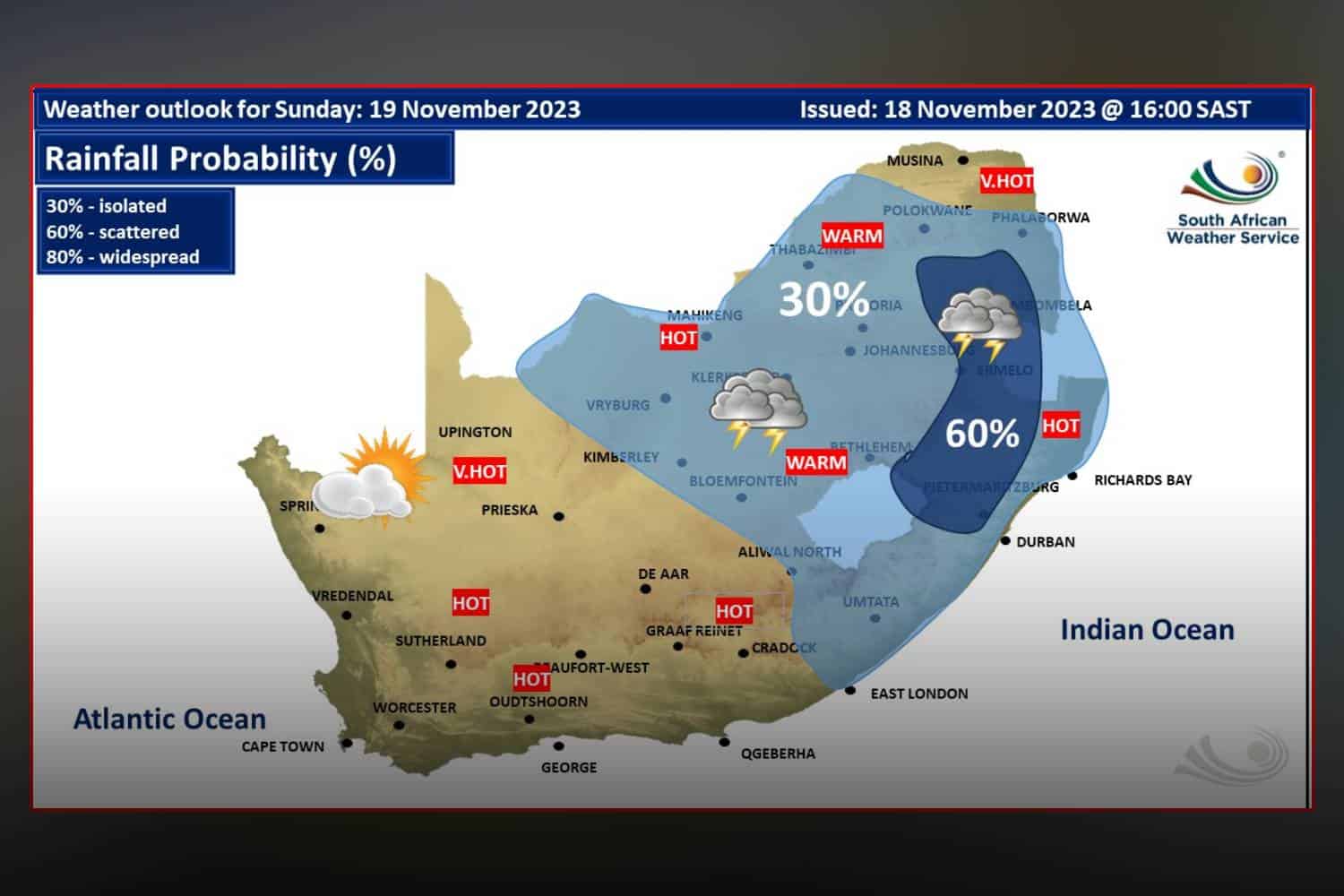
Impact-Based Warnings
A Yellow Level 2 Warning is in effect for severe thunderstorms in the western parts of the North West, northwestern Free State, and western KwaZulu-Natal.
These storms are expected to bring strong damaging winds, hail, and heavy downpours, potentially causing localized damage to informal houses and flooding in susceptible areas.
Fire Danger Warnings
Extreme high fire danger conditions are forecasted for the central Northern Cape and Beaufort West municipality in the Western Cape.
Advisories
A heatwave with persistently high temperatures will affect most parts of the Eastern Cape until Tuesday, extending to the lowveld of Mpumalanga, Limpopo Province, and extreme northern parts of the City Of Tshwane in Gauteng until Wednesday.
South Africa weather forecast: Here’s what to expect on Sunday, 12 November 2023
Eastern Cape
In the eastern half, the morning will start with fog patches south of the escarpment. The day will be partly cloudy to cloudy and warm, with a chance of drizzling along the coast and adjacent interior. Isolated thunderstorms are expected east of Queenstown. Coastal winds will be light to moderate easterly to south-easterly.
The western half of the Eastern Cape will experience morning fog patches in the north-east, then a fine, windy, and hot to very hot day. It will be partly cloudy and warm along the coast. Coastal winds will be light and variable, turning moderate southeasterly to easterly.
Free State
The Free State will have partly cloudy, windy, and hot weather with isolated afternoon showers and thundershowers.
Gauteng
Gauteng will be hot in the north, fine and warm elsewhere, becoming partly cloudy with isolated showers and thundershowers in the afternoon. The UVB sunburn index is high.
KwaZulu-Natal
Morning fog over the interior will give way to partly cloudy skies. The day will be warm to hot, with scattered showers and thundershowers but isolated in the east. Coastal winds will be moderate easterly to north-easterly, freshening in the afternoon and turning moderate to fresh south-westerly in the south by evening. The UVB sunburn index is extreme.
Limpopo
Limpopo will be partly cloudy and hot to very hot, with isolated thundershowers from the afternoon, except in the Lowveld. Scattered thundershowers are expected over the southern parts.
Mpumalanga
Mpumalanga will be very hot in the Lowveld. The rest of the province will be partly cloudy and warm to hot, with isolated showers and thundershowers from the afternoon, but scattered on the central and eastern Highveld.
North West
The North West will be partly cloudy and warm to hot, with isolated showers and thundershowers.
Northern Cape
The Northern Cape will be cool along the coast but otherwise fine, windy, and hot to very hot. It will become partly cloudy in the afternoon with isolated thundershowers in the extreme east. Coastal winds will be light to moderate south to south-easterly, becoming fresh in the afternoon.
Western Cape
The Western Cape will be partly cloudy to cloudy and cool to warm, with morning fog along the west and southwest coast. The interior will be fine and warm.
Coastal winds will be light and variable, becoming moderate to fresh northerly to north-westerly in the west and south-west. The UVB sunburn index is very high.
We will continue to update this report as more information becomes available. Stay tuned for the latest weather news and advisories.