
Here’s a comprehensive outlook on the South Africa weather forecast for Monday, 30 October 2023.
Weather warnings and advisories to take note of on Monday, 30 October 2023
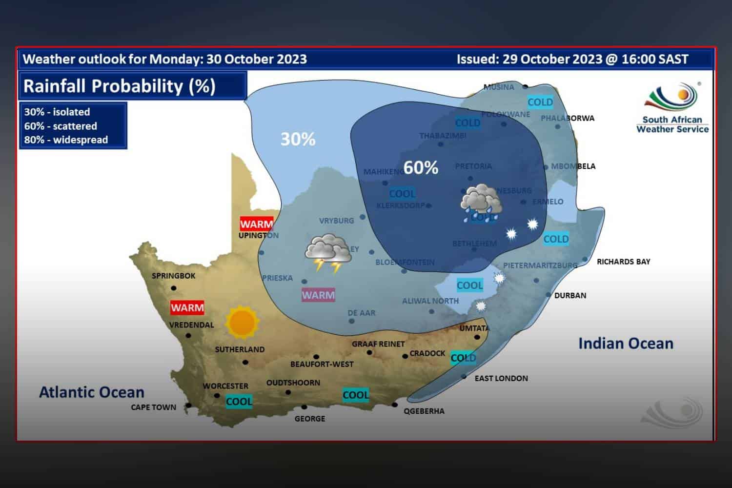
The South Africa weather forecast for Monday indicates a range of severe weather conditions, including damaging winds, thunderstorms, and disruptive snowfall in various provinces.
Impact-based Warnings
The South African Weather Service (SAWS) has issued multiple impact-based warnings for Monday, 30 October 2023.
Damaging winds that hinder navigation at sea are anticipated between Alexander Bay and Plettenberg Bay.
In the north-eastern areas of the Northern Cape and the south-western sectors of the North-West Province, severe thunderstorms with heavy downpours and small hail are expected.
Additionally, disruptive snowfall that could lead to closed passes, dangerous driving conditions, and loss of vulnerable livestock is predicted for extreme western KwaZulu-Natal and extreme eastern Free State.
An intense cut-off low-pressure system will affect southern, central, and eastern parts of the country until Wednesday.
The public and small stock farmers should prepare for cold to very cold, wet, and windy conditions across several provinces including Eastern Cape, KwaZulu-Natal, Free State, Mpumalanga, Gauteng, Limpopo, and North West Province.
Fire danger warnings
Fire danger remains a concern as well. Extremely high fire danger conditions are forecasted for the Kamiesberg of the Northern Cape, Matzikama and Cederberg Local Municipalities of the Western Cape, as well as the Kagisano-Molopo Local Municipality of the North-West Province.
South Africa weather forecast: Here’s what to expect on Monday, 30 October 2023
Eastern Cape
The province will be divided between the western half experiencing partly cloudy, windy and cool conditions, and the eastern half facing isolated showers and thundershowers, and light rain along the coast.
Free State
Extreme eastern parts of the province are under a yellow level 2 warning for disruptive snowfall. The weather will be windy and cold to very cold, featuring scattered showers and thundershowers.
Gauteng
The province is expected to be cloudy and cold with scattered showers and thundershowers. Areas in the north may experience slightly cooler temperatures.
KwaZulu-Natal
Extreme western parts are warned for disruptive snowfall. The weather will generally be cloudy and very cold, especially over the western high-ground, with isolated to scattered showers and rain expected.
Limpopo
Morning fog is expected along the escarpment. The weather will be cool to cold with isolated showers and thundershowers, becoming more scattered in the east and north of the province.
Mpumalanga
Residents should anticipate morning fog over the Highveld. The weather will be cloudy and cold, featuring scattered showers and isolated thundershowers in the Lowveld. Along the escarpment, extremely cold conditions with possible snow are forecasted.
North West
A yellow level 2 warning for severe thunderstorms has been issued for the south-western areas. Overall, the province will be cloudy, windy, and cold to cool, accompanied by scattered showers and thundershowers.
Northern Cape
Fine weather is predicted in the west, while the remainder of the province will see partly cloudy, windy, and cool to warm conditions. Isolated to scattered showers and thundershowers are expected.
Coastal areas will be hot, and fresh to strong south-easterly to easterly winds could lead to possible dust storms.
Western Cape
Eastern parts will be partly cloudy, while the rest will experience fine and cool to warm conditions. Strong to gale-force south-easterly to easterly winds are expected along the coast, especially on the south-west coast.
We will continue to update this report as more information becomes available. Stay tuned for the latest weather news and advisories.