The South Africa weather forecast for Friday foretells a day of mixed conditions, ranging from severe thunderstorms to very high UV indexes.
Weather warnings and advisories to take note of on Friday, 3 November 2023
As the week draws to a close, South Africans across various provinces can expect diverse weather conditions this Friday.
A Yellow Level 2 Warning sets the tone for the day, predicting severe thunderstorms that are likely to cause localised damage and disruptions, particularly over the central and western parts of the Eastern Cape, extending to the eastern parts of the Northern Cape.
South Africa weather forecast: Here’s what to expect on Friday, 3 November 2023
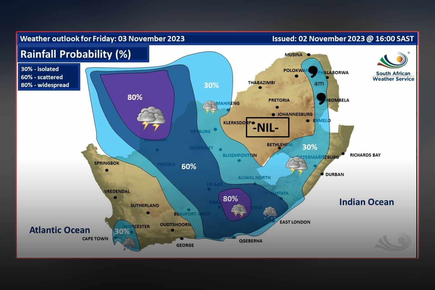
Eastern Cape
Both halves of the Eastern Cape will see hot temperatures, with the western part expecting showers and thunderstorms by afternoon. Coastal areas will have moderate to strong easterly winds, shifting westerly later on.
Free State
In the Free State, residents will wake to morning fog in areas within the extreme east, later giving way to partly cloudy skies and warm temperatures.
The western and extreme eastern regions should prepare for isolated showers and thundershowers, accompanied by windy conditions in the west.
Gauteng
The atmosphere over Gauteng will be partly cloudy, yet temperatures will remain warm. The high UVB sunburn index is a clear indicator that residents should take precautions against sun exposure.
KwaZulu-Natal
KwaZulu-Natal is set to experience morning fog over the interior, transitioning to partly cloudy conditions with cool to warm temperatures. Isolated showers and thundershowers are expected in the south-west and Midlands. Coastal areas should anticipate moderate to fresh easterly to north-easterly winds, which are likely to pick up speed in the afternoon.
The UVB sunburn index will be very high, urging a cautious approach to outdoor activities.
Limpopo
Limpopo’s forecast suggests cloudy skies in the east, with morning fog patches and occasional drizzle along the escarpment. The rest of the province will see partly cloudy skies with cool to warm temperatures.
Mpumalanga
In Mpumalanga, the east can expect cloudy skies with morning fog patches and drizzle on the escarpment. However, the day will generally be partly cloudy and cool, turning warm in the Lowveld.
North West
For those in the North-West Province, the day will begin fine in the central and eastern parts. However, warmth and partly cloudy skies are expected to prevail, with isolated showers and thundershowers developing in the northern and western regions.
Northern Cape
The Northern Cape’s weather narrative speaks of cloudy and cool conditions in the western parts, with morning fog in the extreme northwest. As the day progresses, conditions will become partly cloudy and warm to hot with isolated to scattered showers and thundershowers in the east, where it will also be windy.
Coastal areas should prepare for light to moderate westerly to north-westerly winds, becoming fresh southerly to south-westerly by the evening. Central areas are advised of extremely high fire danger conditions.
Western Cape
The Western Cape will see cloudy and cool conditions along the coast with the likelihood of light rain in the southwest towards the evening. Inland areas will be partly cloudy and warm, with temperatures climbing higher over the eastern interior. Isolated showers and thundershowers are predicted over the extreme north-eastern interior from the afternoon.
Coastal winds will be moderate to fresh north-westerly, spreading to the south coast and intensifying along the southwest coast. A shift to southerly to south-westerly winds is expected by evening. Residents should be wary of the very high UVB sunburn index, indicating a strong potential for sunburn.
We will continue to update this report as more information becomes available. Stay tuned for the latest weather news and advisories.