Here’s a comprehensive outlook on the South Africa weather forecast for Friday, 24 November 2023.
Weather warnings and advisories to take note of on Friday, 24 November 2023
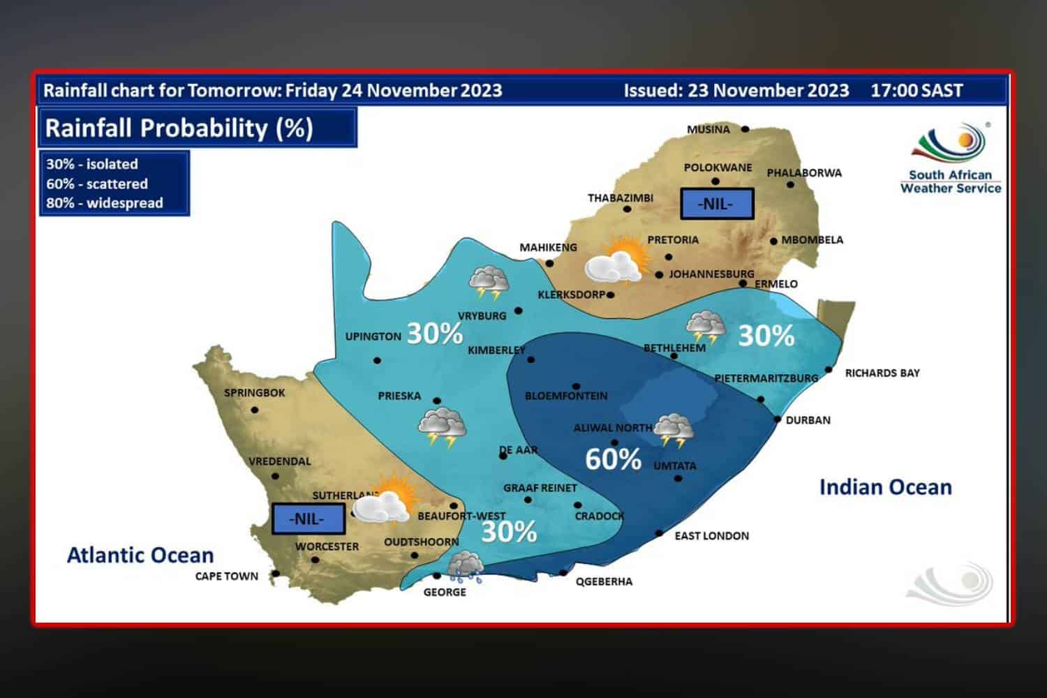
The South Africa weather forecast for Friday reveals a series of severe weather alerts, including thunderstorms and high fire danger conditions across various provinces.
Impact-Based Warnings
The eastern parts of the Northern Cape and southern KwaZulu-Natal are under a Yellow Level 2 Warning, indicating the possibility of severe thunderstorms.
These storms may bring strong, damaging winds, heavy downpours, and a mix of small and large hail, leading to potential damage to vehicles and structures.
Fire Danger Warnings
Exceptionally high fire danger conditions are forecasted in specific regions, including the eastern parts of Northern Cape, the western Free State, eastern areas of the North-West Province, northeastern parts of KwaZulu-Natal, northeastern Mpumalanga, and sections of Limpopo.
Advisories
Heatwave conditions with sustained high temperatures are anticipated in the eastern parts of the Eastern Cape, western KwaZulu-Natal, Gauteng, Limpopo, Mpumalanga, Free State, North-West Province, and northeastern Northern Cape, continuing until Tuesday.
South Africa weather forecast: Here’s what to expect on Friday, 24 November 2023
Eastern Cape
In the eastern half, warm conditions along the coast will give way to hot temperatures inland, under partly cloudy skies. Isolated to scattered showers and thundershowers are forecasted.
In the west, the day will be partly cloudy and hot, with cooler conditions along the coast. Isolated showers and thundershowers are expected, becoming more widespread along the coast.
Free State
Conditions in the Free State will be fine but will turn partly cloudy. The region is set to experience hot to very hot temperatures, with isolated showers and thundershowers, becoming scattered in the central and western parts.
Gauteng
The province is expected to experience partly cloudy and hot weather, with isolated showers and thundershowers in the afternoon. The UVB sunburn index is predicted to be extremely high.
KwaZulu-Natal
The day starts fine and hot to very hot, with extreme heat in northern areas. The afternoon will see partly cloudy conditions with isolated showers and thundershowers, becoming scattered in the south. Coastal winds will shift from a moderate north-easterly to a fresh south-westerly from the south in the afternoon.
Limpopo
The day will be fine and hot to very hot, with extreme heat in some areas of the Lowveld. Isolated thundershowers are expected in the afternoon, especially in the southern and central regions.
Mpumalanga
Initially fine and warm to very hot, especially in the Lowveld, the region will become partly cloudy later in the day. Isolated showers and thundershowers are anticipated, particularly in the southern part of the province.
North West
The weather will be fine at first, turning partly cloudy and very hot later, with isolated afternoon showers and thundershowers expected.
Northern Cape
Along the coast, it will be cool and cloudy at first, transitioning to partly cloudy and warm to hot conditions inland. The eastern parts of the province can expect very hot temperatures and isolated showers and thundershowers in the afternoon.
Western Cape
The province will see cloudy and cool weather along the south coast with potential light rain in the morning. Other areas will experience partly cloudy skies and warm to hot temperatures, with the eastern interior becoming hot. Coastal winds will be moderate to fresh north-westerly to westerly, becoming southerly to south-westerly in the afternoon.
We will continue to update this report as more information becomes available. Stay tuned for the latest weather news and advisories.